myAIP VFR lite
100+
Downloads

Everyone
info
About this app
myAIP is a all-in-one application to assist you in preparing your VFR flights in France and in a large part of Europe!
It provides all the information and aeronautical safety for VFR with:
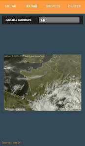
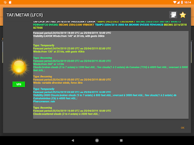
✔ TAF, METAR, SIGMET, raw and decoded (worldwide)
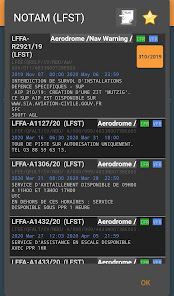
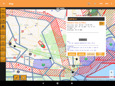
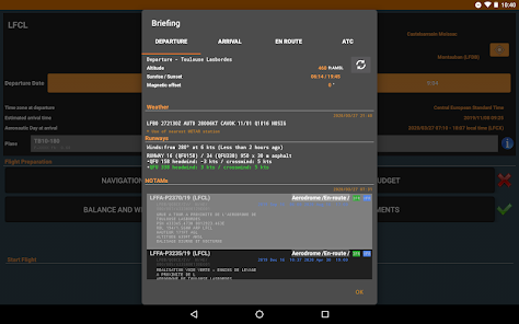
✔ NOTAM for airfields et FIR (worldwide);
✔ GRAMET
✔ Display Visual Approach Charts VAC (France only), with updates following Airac calendar;
✔ Display AIP Supplements (France only);
✔ AZBA aeras for military activity (France only);
✔ Manage favorites and offline reading.
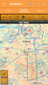
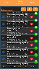
Create your flight plan simply,
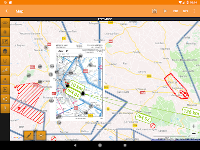
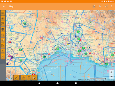
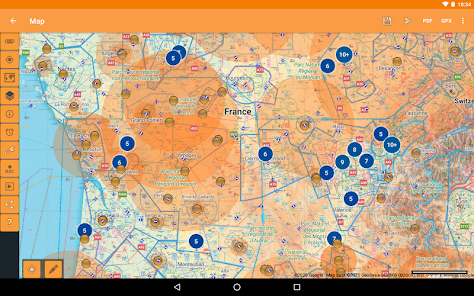
✔ Updated Google Map.
- Many airfield across Europe (France, UK, Germany, Italy, Spain, Belgium, Netherland, ...)
- Add your own overlay
- Beacons NDB, VOR, VOR-DME et TACAN,
- Automatically add turning point when designing a flight path,
- Automatically look for the closest airfield to your flight path.
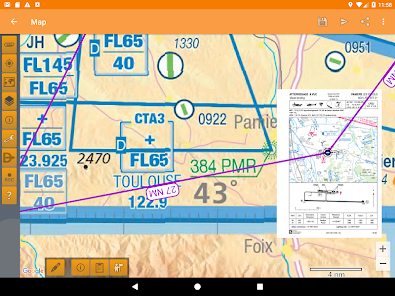
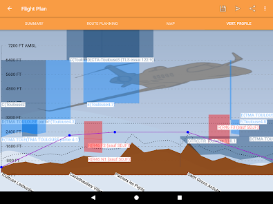
✔ Vertical altitude profil with airspace projection and ground,
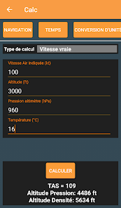
✔ Help define radionavigation parameters ;
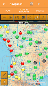
✔ Automatically find nearby airfields;
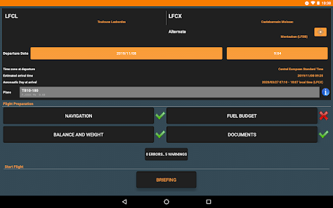
✔ Summary of the collected information for your flight in one single pane;
✔ Send all the collected data (package ZIP) to your email or print directly;
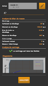
✔ Aircraft (DR300,DR400-{120,140,160,180},DA20,DA40,C152,C172,TB10)
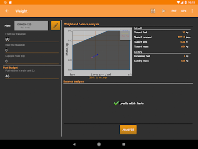
✔ Weight an balance
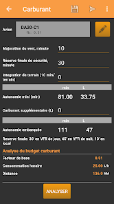
✔ Fuel budget
✔ Compute aeronautical night;
✔ Connect to external device (e.g. for ADS-B)
And more,
✔ VAC are cached for offline access (in your Download directory)
✔ You can add in the database your own waypoints for easy reuse in future flight plans;
✔ Works on tablets and phones!
✔ Checking of the validity of information (VAC, METAR/TAF, ...)
(myAIP lite is the demo version of myAIP. The full version includes in addition
✔ Free airspace layer for France
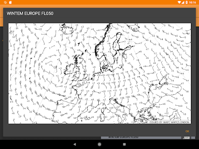
✔ WINTEM and TEMSI maps (France and Europe);
✔ Additional Aeronautical products displayed on the map
✔ Export flight plan to GPS Exchange .gpx
✔ Export flight plan, fuel budget and weights balance to PDF file
✔ the project file can be stored on the cloud for an access from any of your devices
It provides all the information and aeronautical safety for VFR with:
✔ TAF, METAR, SIGMET, raw and decoded (worldwide)
✔ NOTAM for airfields et FIR (worldwide);
✔ GRAMET
✔ Display Visual Approach Charts VAC (France only), with updates following Airac calendar;
✔ Display AIP Supplements (France only);
✔ AZBA aeras for military activity (France only);
✔ Manage favorites and offline reading.
Create your flight plan simply,
✔ Updated Google Map.
- Many airfield across Europe (France, UK, Germany, Italy, Spain, Belgium, Netherland, ...)
- Add your own overlay
- Beacons NDB, VOR, VOR-DME et TACAN,
- Automatically add turning point when designing a flight path,
- Automatically look for the closest airfield to your flight path.
✔ Vertical altitude profil with airspace projection and ground,
✔ Help define radionavigation parameters ;
✔ Automatically find nearby airfields;
✔ Summary of the collected information for your flight in one single pane;
✔ Send all the collected data (package ZIP) to your email or print directly;
✔ Aircraft (DR300,DR400-{120,140,160,180},DA20,DA40,C152,C172,TB10)
✔ Weight an balance
✔ Fuel budget
✔ Compute aeronautical night;
✔ Connect to external device (e.g. for ADS-B)
And more,
✔ VAC are cached for offline access (in your Download directory)
✔ You can add in the database your own waypoints for easy reuse in future flight plans;
✔ Works on tablets and phones!
✔ Checking of the validity of information (VAC, METAR/TAF, ...)
(myAIP lite is the demo version of myAIP. The full version includes in addition
✔ Free airspace layer for France
✔ WINTEM and TEMSI maps (France and Europe);
✔ Additional Aeronautical products displayed on the map
✔ Export flight plan to GPS Exchange .gpx
✔ Export flight plan, fuel budget and weights balance to PDF file
✔ the project file can be stored on the cloud for an access from any of your devices
Updated on
Safety starts with understanding how developers collect and share your data. Data privacy and security practices may vary based on your use, region, and age. The developer provided this information and may update it over time.

No data shared with third parties
Learn more about how developers declare sharing

No data collected
Learn more about how developers declare collection


